|
Grading and difficulty
The Discerning Traveller programme of walking tours has been designed
to cater for a range of abilities and preferences. 'Difficulty' of a walk
or hike is not a single property. At least 5 distinct features of the
walk itself can contribute to how difficult a walk is (or feels). These
are:
- Distance walked per day;
- Gradients;
- Height gained and lost;
- The nature of the trail surface; (e.g. hard, stony, boggy,
slippery, even, asphalt etc.);
- The skill in navigation needed.
To these one must add the varying levels of fitness and experience that
the walker him/herself possesses. In spite of this complexity we try to
operate a simple grading system to enable customers to select a tour that
suits their level of fitness, energy and experience. None of our hikes
is as easy as 'a walk in the park' and none of them is a mountaineering
expedition!
'Easy' grade walks
are intended for those in good general health who periodically spend a
day or a weekend out walking, or take some other fairly regular form of
exercise, but may not have been on a walking tour before. Distances average
8 to 10 miles (4 to 5 hours) per day over fairly gentle terrain although
there may be the odd longer or more tiring day. Little experience of navigation
is required, but some basic map reading ability, or at least aptitude,
is desirable.
'Moderate' grade
walks are best enjoyed by those who take regular exercise and can cope
with days averaging about 12 miles (6 hours) over level or hilly terrain,
again with the occasional longer or harder day. Navigation/map reading
skills are as for 'Easy' grade, but the greater distance covered makes
accurate map reading more important.
'Demanding' grade
walks are for experienced hikers only. If distance was the criterion they
would include days of 16 miles (8 hours, occasionally more) on paths or
tracks over steep or rough ground. However as is made clear below, our
Demanding grade walks are not for the most part classified on the basis
of distances covered but on other criteria, such as gradients, amount
of ascent and descent per day, and the nature of the surface.
Navigation on our demanding tours may require the use of a compass as
well as the map. Some of the walking may be over pathless ground. Some
days on our 'Demanding' grade tours may include short and usually avoidable
scrambling sections. This is made clear in the route descriptions.
'Scrambling' means that hands as well as feet are needed for movement
along a trail over rocky terrain. It is intermediate between walking and
rock climbing. n.b. scrambling does not mean 'vertigo-inducing'!
Top of page
The table below lists our tours approximately in order of increasing difficulty,
however we emphasise that most days on most tours can if preferred be
shortened or extended. We provide directions in the route notes to enable
you to do either of these. The table includes additional notes to help
you make a choice. Click on the tour name to transfer to the page for
that tour.
Our Offa's Dyke Path tour is available as various
options which range from easy to demanding. See the tour
page for that tour and the Factsheet FSO (order via our Further
Information page).
'Easy' and 'Easy to moderate' grade:
Cotswold Villages
Distances short to moderate Surfaces usually grassy or earthy, in places
muddy after rain. Rarely stony. Gradients low to moderate, steeper between
Chipping Campden and Winchcombe (last 2 days of C8). Routefinding more difficult
than on our other 'easy' tours on account of abundance of 'field paths'
and sometimes confusing waymarks.
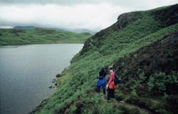
Pembrokeshire Coast: Skomer & St.
David's
Days to 17km/11 miles. Well waymarked coast path. Trails less steep
than Dorset coast.
Jurassic Coast of Devon and Dorset
Days to 17km/11miles. Well waymarked coast path. Steep ascents and
descents. On most days walks can be shortened by using buses.
Lake District Valleys
Days short (up to 8 miles) but can readily be extended. Surfaces rough
and stony, which some may find difficult. Gradients moderate. Paths
well-used and routefinding generally easy, although there are no absolutely
no signposts or waymarks on open (unfenced) ground which comprises
most of the area. On the 7-night tour there are 2 days with options
ranging from easy to demanding.
'Moderate' grade
Dorset Coast Path and Purbeck Ridgeway
Days short (up to 14km/9 miles). Routefinding mostly easy, especially
on coast path and ridgeway. Surfaces firm earthy or grassy, can be
slippery (slick) in wet. Gradients frequently steep or very steep.
Repeated ascents and descents make some days tiring.
Seven Sisters and Weald of Kent
On the easy side of moderate grade. On South Downs Way (Days 2 and 3) and
on Saxon Shore Way (Day 5) days to 20km/12 miles with steep ascents and
descents. In the Weald (Days 6 and 7) careful routefinding is needed on
field paths. All days can be shortened by using public transport.
North Pembrokeshire Coast
As on other coastal walks (eg Dorset and Cornwall) repeated short
but steep ascents and descents make this walk much more tiring than
you might expect from the distances. Longest day 14 miles, but can
be shortened to 11 miles without spoiling the walk. Surfaces grassy
or earthy, rocky on detours to minor summits. Very little asphalt
except through town of Fishguard and on minor roads around St Davids.
Cornwall Coast: Lands End & St Ives
As on other coastal walks (eg Dorset and Pembrokeshire) repeated short
but steep ascents and descents make this walk much more tiring than
you might expect from the distances and maximum altitude (less than
300m/1000 feet). Many walkers find days 2 (10 miles) and 3 (12 miles)
tiring; but Day 3 can readily be shortened. Routefinding usually easy
on the coast, but on our inland variations close attention to the
map and route notes are needed. Surfaces firm, often grassy. Can be
slippery in wet. Some sections suffer from overgrown and spiny vegetation
(gorse), so long trousers are advised on those days (notably Days
2 & 4).
Shropshire Hills and Ludlow
Distances up to 12 miles (on Day 5), but generally days not found too long
by most walkers. Unfrequented nature of these hills and patchy waymarking
means you do have to have your routefinding skills up to scratch! Gradients
occasionally steep, notably on Caer Caradoc walk and Lightspout valley (both
Day 2 options). Surfaces grassy or earthy, very stony on Stiperstones ridge
(Day 4). Some asphalt sections on roads with little traffic.
Cornwall: Polperro & Fowey
Routefinding easy, mostly well waymarked and signposted. Steep gradients
on coast path. Care needed at some narrow sections.
Top of page
'Demanding' grade:
None of these walks are classified in this group on the basis of the
daily distances alone, which are moderate. You need routefinding skills
appropriate to mountainous terrain subject to low cloud and resultant
minimal visibility.
You also need enough experience of independent hiking to be able to judge
when it is advisable to turn back or abandon a walk on account of weather
or cloud conditions. We in Britain live not that far south of the Arctic
circle, and above 2000 feet/600 metres conditions can rapidly revert to
sub-Arctic!
Cornwall: Tintagel Coast with Bodmin Moor extension
On coastal sections (Days 2 to 6) there are some long steep ascents
and descents and care is needed on some narrow sections. Coast path is
well waymarked. All coastal days can be shortened by using local buses.
On the higher parts of Bodmin Moor (Days 7 and 8) there is little waymaking
and some pathless sections where basic compass skill is desirable and
in bad weather essential, but easier low-level alternative routes are
available on these days in case of bad weather or your preference. If
necessary (e.g. in very bad weather) customers can also travel by taxi
with their baggage.
We do not accept single travellers on the Bodmin Moor extension.
Lake District Mountains
Routefinding skills are particularly important here. The paths and trails
are well-used and well-defined, but there are no waymarks or signposts
at all anywhere on open ground in the Lake District (this is effectively
a regulation of the National Park authority). So you have to know where
you are heading! In addition low cloud on the mountains is common and
quickly can reduce visibility to 40 metres or less. 50% of the time the
summit of Scafell Pike (3210 feet; an option for Day 5) is in cloud, but
lower level options are available on this and on other days.
We insist that customers on this tour check the local telephone weather
and cloud base forecast each morning and advise you to travel with the
baggage if the forecast is bad. We remind you that the great A. Wainwright
never walked in the mist (cloud) if he could avoid it!
Rough, stony and sometimes rocky surfaces are the norm, with prolonged
and often steep ascents and descents, amounting to 12,000 to 15,000 feet
/ 3,500m to 4,500m during the week. No scrambling required unless you
choose the low level Wastwater Screes option on Day 5 (inadvisable in
wet weather), or the Mickledore route to Scafell Pike (we advise an easier
route).
For safety reasons we do not accept bookings from single travellers
for our 'Demanding' grade tours.
|