|
||||
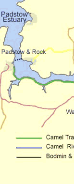
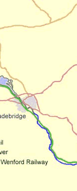
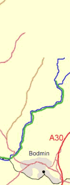
| The Camel Trail
The Camel Trail, available free 365 days of the year, winds through some of Cornwall's most beautiful and little-known countryside. Cornwall County Council converted 11 miles of disused railway beside the River Camel from track bed to trail, linking the towns of Bodmin, Wadebridge and Padstow. An extension follows the river towards Camelford. |
||||
| All Cyclists using the Camel Trail, please observe the Trail Code | ||||
| The Camel Trail Cycling Code
|
||||
| CYCLE ROUTES using the Camel Trail | ||||
|
Wadebridge - Padstow - Wadebridge |
| Route 1. Wadebridge - Porthilly - Padstow - Camel Trail - Wadebridge |
| LENGTH: 15.8 miles (25.5 km) Grade: Easy |
| THE AREA A pleasant cycle ride involving a ferry crossing at Padstow taking a route to the north of the Camel estuary to Rock, ferry to Padstow and the Camel Trail back to Wadebridge. THE ROUTE |
| Route 2. Wadebridge - St. Breock - Withiel - Camel Trail - Wadebridge |
| LENGTH: 14.7 miles (23.5 km) Grade: Easy to Moderate |
| THE AREA This route heads south east out of Wadebridge towards the hamlet of Polmoria then on towards St. Breock downs passing the wind turbine farm en-route, some off-road riding is encountered along a rough bridleway at Tregustick and a ford will have to be crossed just afterwards. The route then goes on towards Ruthernbridge and the Camel Trail back to Wadebridge. THE ROUTE |
| Route 3. Padstow - Trevone - St. Issey - Old Town Cove - Camel Trail - Padstow |
| LENGTH: 18.8 miles (29 km) Grade: Moderate |
| THE AREA For each climb on this route you are rewarded with views of north Cornwall's spectacular coastline. This circular route takes you out of Padstow to Trevone and Constantine Bay and around to St. Issey mostly via quiet country lanes - The route then joins the Camel Trail to return to Padstow. THE ROUTE |
| Route 4. Wadebridge - Lanivet - Helman Tor - Camel Trail - Wadebridge |
| LENGTH: 20 miles (33 km) Grade: Intermediate |
| THE AREA Part of this route, from Lanivet to Helman Tor, traces the path of the early Christian pilgrims along the Saints Way from coast to coast. THE ROUTE |
| Route 5. Bodmin - Cardinham Woods - Blisland - Camel Trail - Bodmin |
| LENGTH: 20 miles (33 km) Grade: Strenuous |
| THE AREA Many parts of Cornwall has few trees but this route takes you through the wooded valleys of the River Fowey and the River Camel. THE ROUTE |
| Route 6. Poley's Bridge - Roughtor - Camelford - Wenfordbridge - Poley's Bridge |
| LENGTH: 20 miles (33 km) Grade: Strenuous |
| THE AREA Passing through a pleasant village perched on the edge of Bodmin Moor you reach the second highest peak in Cornwall. The surrounding countryside is littered with ancient remains. You visit Camelford, in the market place stands the market house with a cupola crowned by a golden camel. THE ROUTE |
|
Boscastle Tourist Centre Tel 01840 250010 FAX 01840 250010 |
| BRIDGE CYCLE HIRE Tel: (01208) 814545 Private Parking (FREE) Park & Ride Tel: (01208) 814303 Mobile: 0378 737456 |
| BIKE SMART - www.cameltrailbikes.com Cycle hire for the Camel Trail in Wadebridge - 01208 814 545 or Email info@bikesmart.eu |
| Kernow Scopes Telescope & Binocular Specialists 2 Foundry Court, WADEBRIDGE Cornwall PL27 70N Tel/Fax: (01208) 812883 |
| Padstow Cycle Hire Ltd - www.padstowcyclehire.com 01841 533533 South Quay Padstow, Cornwall PL28 8BL Ladies & Gents Cycles Mountain Bikes Childrens Seats Tandems Tandems Trailers Helmets Open daily from 8.30am Conveniently located at South Quay car park, 100 yds from the start of the Camel Trail BOOKINGS WELCOME |